| Bicycling Life |
About Our Site
Issues & Editorials
Solutions for Little
Problems,
Adjustments, and Repairs.
Using Bikes in Everyday
Life
Commuting & Errands
Cycling for Fun &
Health
Street Smarts for Bicyclists
Safety Issues
Advancing Cycling Issues
Getting Involved
Position Papers
Research and
Source Documents
|
| |
|
  Sierra
Spring 2000 Sierra
Spring 2000
|
Spring Tour in the Sierra 20,21 May 2000
This year, determined not to miss the opening weekend of the
Sierra mountain passes, we picked the weekend of 20 May expectating a bit of walking over
snow in the worst case because the roads had not yet been reported as opened.
As it was, the preceding week was cold and wet with snow in the mountains so roads that
had already opened were again closed. On Thursday the forecast was for a clear and warming
weekend while on Friday the forecast was for a scorching weekend, the first one this
spring.
| Brian Cox, John Woodfill and I drove across the San Joaquin Valley to
Sonora in the Sierra Nevada foothills, located on highways 49 and 108 and roads that
connect to Yosemite Park and Tioga, Sonora, and Ebbetts Passes, it lies at about 1800ft,
1000ft above the gorges of the Stanislaus and Tuolumne Rivers, to the north and south. All
passes were open and, because Tioga Pass in Yosemite Park is especially beautiful in
spring with its many waterfalls and streams when the snow is still thick, we chose to go
that route going east and return over Sonora Pass. |
 |
A large Harley Davidson meet in Sonora filled most accommodations, including our usual
Sonora Gold Lodge, so we found space at Miner's Motel, from which we had launched some
great rides in the 1970's with notable USCF racers of that time. It's partly the nostalgia
of heady days past, when we sprinted for every excuse on the way over the big hill, that
still makes this such a great adventure. After the usual good dinner at Wilma's Flying Pig
on the main drag, we got a good nights sleep in the cool mountain air that was scheduled
to get hot tomorrow.
| We headed up Sonora pass HWY108, and just past town, turned off on
Tuolumne Rd heading southeast a mile or so to Wards Ferry Rd. Wards Ferry, as other river
crossings over the Mokelumne, Stanislaus and Tuolumne rivers, don't look like much today
but in their time these roaring and rugged canyons posed major barriers to north-south
travel. Today their white waters that we knew in years past are submerged beneath
backwaters of huge artificial lakes and are crossed on bridges built in more than oriental
splendor by these huge projects. Wards Ferry is the last of these to still show its
pioneering heritage although it has its high bridge thanks to Don Pedro Reservoir dam 15
miles away. |
 |
As we headed south on Wards Ferry Rd into the rising sun through the still lush green
fields and pastel dark green oaks, grazing sunlight lit a fine fuzz of grass like green
felt in the myriad cracks of the asphalt on this little used road. As we climbed, pavement
dwindled from a striped two lane road to a one lane patchwork. We crested a ridge at
2000ft behind which the Tuolumne river flowed 1200ft below. The asphalt here is a rare
classic today, with a million patches with no hint of what is not a patch. At the first
plateau, a watering trough, that had once been a refrigerator lying on its back, was now a
plastic trough, but still full of water. Below the single hairpin turn we came upon fresh
hot mix asphalt that the highway department finally decided to lay over the patchwork that
today surely costs more to maintain than a coat of new pavement.
Fishermen were launching boats as we crossed the bridge (816ft) as hundreds of swallows
darted about, constructing mud nests under the deck. Grunt! Right after the bridge the
road abruptly begins its climb, traces of the hand laid random cobbles still visible here
and there. For our early tours, the road still had exposed cobbles with a smattering of
asphalt between the irregular stones. It was rough and the bridge was at the bottom of the
gorge over the white water of the Tuolumne, now a placid lake with driftwood gathering in
coves.
After a bit of climbing the driveway width one lane road widened a bit and its grade
became more civilized. Rocky cliffs gave way to grassy slopes with pines and oaks. After a
few turns into side ravines we broke out into Deer Flat (2579ft), a lovely broad meadow,
lush with water and grass with a couple of old white farm houses in the shade of large
oaks. We turned up Deer Flat Rd to cross the ridge at 3000ft into Groveland. As always, we
looked both ways when crossing the right of way of the Hetch Hetchy RR that was used to
build O'Shaughnessy Dam across John Muir's Grand Canyon of the Tuolumne, rest his soul. It
was a canyon to rival Yosemite that now serves as principal water supply for San
Francisco.
After a refreshment at the store we headed up HWY120 toward Crane Flat entrance,
marveling at old HWY120 that goes up and down through myriad valleys parallel to the
smooth fast new highway. I recall riding that road both up and down, on which it wasn't
clear which direction was more work. We crossed the south fork of the Tuolumne three times
on this stretch, the last time at a roaring cascade that descends at about 45 degrees from
as far up as one can see through the froth while vanishing below over the edge on its way
to the central valley to join the San Joaquin River.
We paid the exorbitant $10 fee per person even though a car full of bicyclists with
bikes on the rack pass for he same amount. Think park positive I said to myself, as we
bought a Pepsi from the $1.50 vending machine. Across the entrance area, on the left, a
road with a "Authorized Vehicles Only" heads down to the maintenance yard and
ranger residences. This is the Old Big Oak Flat Rd that is no longer open to motor
vehicles. After descending about a half mile, a narrow one lane road with a "Do Not
Enter" sign veers up and off to the left just above the utility yard. This IS the
road and from appearances, not much ever goes this way anymore.
With no traffic and where the silence is broken only by the sound of rushing water and
warbling birds, we crossed Bull and North Crome Creeks in the shade of huge Douglas firs
under which dogwoods were in full bloom with large white four petal blossoms and pale
green leaves that looked almost anemic from lack of sunlight. After a good drink of ice
cold water we headed up the hill toward the Tuolumne Big trees that are only accessible on
foot (or bicycle) today, the road being closed to motor vehicles.
The road was covered with debris from recent rains and showed only a MTB track in soft
spots. Farther up we saw two MTB's lying unattended near the road as we came across the
first snow fields. We stopped at the giant redwood next to the road for the obligatory
photo in front of the more than 20ft diameter trunk. Much German was spoken here, I
suppose because Germans are not averse to taking a walk, and because Europe hasn't had any
giant trees for centuries. From here it's a mile or so to Crane Flat (6200ft) where we
rejoined (new) HWY120.
We backtracked a bit to the Crane Flat store for a snack before heading up toward White
Wolf, the next plateau where we would cross from the Tuolumne to the Merced River basin,
the valley of Yosemite Park with its many waterfalls and huge vertical walls of granite.
On our climb we were serenaded by many western wood peewees who dutifully sang we-pee-wee,
we-pee-wee along with nuthatches, whose call is reminiscent of a miniature duck call.
Marmots didn't make a showing but some ground squirrels and chipmunks were already running
over snow that still covered most of the ground at this elevation. Siesta lake (7980ft)
was just another snowfield as we continued to the White Wolf gap (8400ft) near the top of
this broad ridge.
From here it's about a four mile descent to Yosemite Creek (7400ft) that gave us a
grand panorama to the south of magnificent granite walls, dusted with new snow. It's
mostly rock here, and although water rushes in spring, most of the streams are dry when
the snow is gone, as we discovered on a fall ride here a few years ago. Today the
mountains were roaring with water as we rode with cool sunny weather that could even
produce a chill when a cloud passed on a descent. Tioga Road is a long series of climbs
and descents that can be a disappointment to someone who plans on coasting from the summit
to the valley. Here the forest is a mixture of red and white fir, ponderosa, as well as
cedars while higher up, lodgepole pinesare the mainstay.
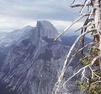
| Yosemite Creek was a roaring froth as it went under the road, but of
course nothing compared to the spectacular Falls into the main valley. From here it's a
few miles up the side of the ridge to Olmsted Point (8422ft) from which we got a side view
of Half Dome that looks like a cliff to be attacked before noon for daytime success.
Brian, who is familiar with many of the challenging climbs of the region, pointed out
various routes to the tops and told anecdotes that characterize these rock climbing
adventures. From the overlook, we rolled down to Tenaya Lake (8160ft) that was still
covered with thawing snow, that is, it had puddles on the ice from melting snow. |
 |
From here its a gradual climb into Tuolumne meadows over a small divide (8452ft) with a
descent into Tuolumne river basin and the meadows that were still covered with snow. Here,
the tent frame for the food store that serves in summer was being erected as we rolled
briskly across the flats and up the gradual grade that took us past 9000ft. Finally we saw
the summit station ahead as we sped up for "the sprint" to 9945ft. Alas, I had
little to offer against John who was "cheating" with his 25 year advantage. I
recall great competitions here from the 1960's and they make it sweet fun to be here
again. We took summit photos before rolling down past Tioga (9638ft) and Ellery (9477ft)
lakes, still covered with ice. From here it's a continuous descent into the canyon to Lee
Vining. Although we had favorable air (a light following breeze) we did not reach the
magic 60mph of which we have often heard.
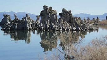
| In Lee Vining (6750ft) we got some vittles, phoned ahead for a motel in
Bridgeport, and rolled down the hill to the shores of Mono Lake with its crusty salt
sculptures and beautiful blue brackish water at 6409ft. We rolled easily to the base of
Conway Summit (8138ft) where a long continuous and scenic grade rises to a broad summit. |
 |
From here we rolled into a light breeze down the valley to Bridgeport (6465ft) along
Virginia Creek. We took turns pushing wind as we rolled briskly into town on the gentle
slope.
After a shower and change into civilian clothes, we savored a delicious Salmon Steak
dinner at the Bridgeport Inn and retired to a good night's sleep in the cool mountain air
after 140 miles and 16000 ft climbing.
Bridgeport looked a bit sleepy, the vacationers not yet having heard the starting bell
for summer. That signal will be sounded next week, the 29th of May on Memorial Day, a good
reason to get there before the rush. The classic tall white Victorian county courthouse
with arched red trim windows was looking fine with its flagpole and cannon on the lawn
behind a white picket fence. If you looked closely though, it needed a paint job (flakes)
and a bit of patching where starlings were nesting in a hole in the wall.
After a hearty breakfast at the Sportsman's Inn, we rolled north out of town on HWY395,
that first heads due west to a turn in the road seemingly a stones throw away but actually
two and a half miles. These fields are a huge drained marsh, lush with grazing grasses on
which beef spends the summer getting fat. All this water gathers in Bridgeport Lake, a
wide spot in the East Walker River. Many marsh birds as well as ducks and geese make this
a breeding ground. We saw cinnamon teal, mallards, coots, Canada geese and the usual treat
of yellow headed blackbirds that we don't see at home. Magpies and crows yacked at us as
we passed while a marmot sunned itself on the top of a fencepost.
From here HWY395 heads up a gentle climb to Devil's Gate Summit (7519ft) through a gap
of red volcanic crags on an the inauspicious saddle where the "forever closed"
Fales Hot Springs are. I have not seen the spa in operation in all the years I have
bicycled here. After a short descent, at Sonora JCT (6950ft), we were back on HWY108
heading west across marshes with waterfowl and yellow headed blackbirds. The road then
descends to the West Walker River before climbing to Pickel Meadows and the USMC Mountain
Warfare training center. Judging from the lack of activity, one might get the
impression the world was at peace, either that or that the Marines were off fighting wars.
In any case, things were mighty quiet.
After following the north side of the valley, the road abruptly heads up Leavitt Creek
with some bumps of 18% grade, leveling out at the site of the former Leavitt Meadows
Store. Just past the Leavitt Meadows Pack Station the road makes a right turn into its
steepest grade of 26% and lets up to about 20% for another quarter mile. The half mile
from the curve is probably the most challenging part of this side of the pass, the rest
being a continual grade between steep sections and one descent. Water is clear cold and
abundant here between sage brush and sparse woods. Farther up we came to one of the
surprises for the first time descender, the steep ess, an ess curve with 26% grade hidden
behind a verge for downhill traffic. We rode up it around the outside to avoid gratuitous
steepness and recalled various exciting descents on wet pavement between snow banks in
past years.
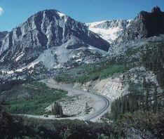
With a cool breeze, climbing went well as we reached Sonora Pass (9624ft) surrounded by
snow banks that were high enough to obscure part of the summit sign. From here the road
descends gently for about a mile next to Deadman's Creek before it dives down the Golden
Stairs past the 9000ft marker and around a pair of ess bends to level off a bit before the
next steep section. The road was in excellent shape with almost no traffic. We were down
to Kennedy Meadows (6500ft) in no time as we passed the uphill challenges of the west
slope at speed. Ray Hosler has some vignettes
of this climb on his web page.
After a few rollers along the creek, we stopped at the Dardanelle Store where things
were as usual except that one of the buildings (not the store) had burned to the ground
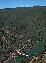
last fall. We sat around and ate before continuing to Clark Fork JCT and the two mile hill
to Donnells Overlook with a 1300ft near vertical drop to the waters of Donnells Reservoir
on the Stanislaus River. Across the valley, the Dardanelle Cones, ancient volcanic
formations, stood high above, decorated with snow on slopes of scree. Swifts flew close by
giving flight a special significance as they they darted past from above the abyss with
aerobatics in a manner appropriate to their name.
From here the road climbs to 6500ft and levels off again at about 6000ft with a few
more ups and downs before a two mile descent to Strawberry (5100ft). Anticipating food at
the big red store at the bottom of the hill, we were surprised to find it closed. We
didn't waste any time, crossed the South Fork of the Stanislaus and continued to Cold
Springs up a two mile hill back up to 5720ft where the store was open.
Then it's pretty much all down or level to Twain Harte where we turned off down
Tuolumne Rd to the city of that name. This is a relatively quiet road in comparison to
HWY108, it is downhill and there is a frosty cone shop at the bottom, important landmarks
to remember. We mistakenly took the BIG cone, realizing only too late that the customers
we had seen were eating medium cones that were almost too much at that. We had to eat fast
to prevent an ice cream runaway in the hot weather we had reached after our long descent.
From here we rode through what is left of one of the largest saw mills in the Sierra,
the West Side, that ran more than 100 miles of 3-foot gauge logging railway on the West
side of the mountains to Cherry Lake, only 20 airline miles away. This railroad was one of
the great loggers with geared Shay and Heisler steam locomotives that live on today on
tourist lines from Georgetown Loop CO to Roaring Camp near Santa Cruz CA. From here
Tuolumne Rd climbs gradually to Ralph, where the Sierra RR crosses from Standard, the base
camp of the Pickering Lumber RR that logged the Stanislaus basin with Standard gauge
Shays. After the top of the grade, we passed Wards Ferry Road to close the loop. In Sonora
we had reached the heat of the valley, packed the car and drove home to the first hot day
of the year. 105 miles, 6030ft.
Copyright 2000 Jobst Brandt
|
  |
|
By
|